|
Lewis & Clark - Corps of Discovery Historical Material
3940 pages of material related to the Lewis & Clark Corps of Discovery expedition of 1804 to
1806. Material includes text, historical volumes, and images of original documents and maps. The disc features Thomas Jefferson papers & correspondences,
transcriptions of the journals of Lewis and Clark, books, and maps.
In 1803 President Thomas Jefferson guided a splendid piece of foreign diplomacy through the
United.States Senate: the purchase of the Louisiana Territory from France. After the Louisiana
Purchase Treaty was made, Jefferson initiated an exploration of the newly purchased land and the
territory beyond the "great rock mountains" in the West. The objectives of the mission were the
establishment of commercial ties with the indigenous people of the Far West and an increase in
the knowledge of the region's geography. Jefferson chose his personal secretary, Meriwether
Lewis to lead the expedition. Lewis in turn solicited the help of William Clark, whose abilities
as a draftsman and frontiersman were stronger than those of Lewis. Lewis so respected Clark,
that he made him a co-commanding captain of the Expedition, even though Clark was never
recognized as such by the government. President Jefferson approved Lewis' choice of Clark as
the co-leader of the planned expedition to the Pacific. The U.S. Army would not reinstate Clark
with his former rank of Captain. He received the rank of 2nd Lieutenant of the Corps of
Artillerists. Lewis always called Clark by the title of "captain" and never told the members of the
Corps of Discovery otherwise. Together they collected a diverse military Corps of Discovery
that would be able to undertake a two-year journey to the great ocean.
Under the command of Meriwether Lewis and William Clark, the Corps of Discovery set forth
from St. Louis on May 14, 1804. The party originally consisted of twenty-nine men, including
Clark's black slave York. In the next twenty-eight months, the Corps of Discovery would travel
more than 8,000 miles through unfamiliar terrain inhabited by an array of indigenous peoples.
Jefferson hoped that Lewis and Clark would find a water route linking the Columbia and
Missouri rivers. This water link would connect the Pacific Ocean with the Mississippi River
system, thus giving the new western land access to port markets out of the Gulf of Mexico and to
eastern cities along the Ohio River and its minor tributaries. At the time, American and European
explorers had only penetrated what would become each end of the Lewis and Clark Trail.
Both captains kept detailed journals that depicted a culturally and geographically diverse Western
landscape, that was rich with natural resources. Their descriptions of vast populations of
fur-bearing mammals would spur the extension of the American fur trade into the upper reaches
of the Missouri River
The expedition made it as far as the Great Bend of the Missouri by the end of 1804. While
camped near the villages of the Mandan and Minnetaree, the Corps enlisted the services of
Toussaint Charbonneau and his Shoshone wife Sacagawea. The following year, the expedition
journeyed up the Missouri, across the Rocky Mountains, and down the Columbia River to the
Pacific Ocean. When the spring of 1805 brought high water and favorable weather, the Lewis
and Clark Expedition set out on the next leg of its journey. They traveled up the Missouri to
present-day Three Forks, Montana, wisely choosing to follow the western-most tributary, the
Jefferson River. This route delivered the explorers to the doorstep of the Shoshone Indians, who
were skilled at traversing the great rock mountains with horses. Once over the Bitterroot
Mountains, the Corps of Discovery shaped canoe-like vessels that transported them swiftly
downriver to the mouth of the Columbia, where they wintered (1805-1806) at Fort Clatsop, on
the present-day Oregon side of the river. At the newly-erected Fort Clatsop, the party suffered
through a dismal winter. The following year all members of the Corps of Discovery returned
along roughly the same route. During the journey only one person, Sergeant Charles Floyd, lost
his life, while another, Jean Baptiste Charbonneau, was born to Sacagawea.
With journals in hand, Lewis, Clark, and the other members of the Expedition returned to St.
Louis by September 1806 to report their findings to Jefferson. Along the way, they continued to
trade what few goods they still had with the Indians and set up diplomatic relations with the
Indians. Additionally, they recorded their contact with Indians and described the shape of the
landscape and the creatures of this western world, new to the white man. In doing so, they
fulfilled many of Jefferson's wishes for the Expedition. Along the way, William Clark drew a
series of maps that were remarkably detailed, noting and naming rivers and creeks, significant
points in the landscape, the shape of river shore, and spots where the Corps spent each night or
camped or portaged for longer periods of time. Later explorers used these maps to further probe
the western portion of the continent.
Meriwether Lewis in 1807 was appointed Governor of the Louisiana Territory and stationed in
St. Louis. Lewis had made many of the arrangements needed to illustrate and publish his journals
of the expedition, but he was never able to work on or provide the manuscript. By 1809, he faced political difficulties and financial problems, as well as family and personal disappointments.
Lewis committed suicide in October of 1809.
William Clark was appointed by President Jefferson to be Superintendent of Indian Affairs for
the Louisiana Territory with the rank of Brigadier General of the Militia. In 1808, Clark became
one of the partners in the St. Louis Missouri River Fur Company. Clark was appointed Governor
of the Missouri Territory in 1810. William Clark died on September 1 1838.
DISC INCLUDES:
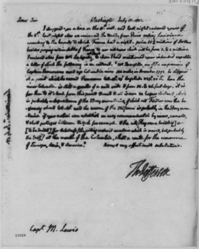
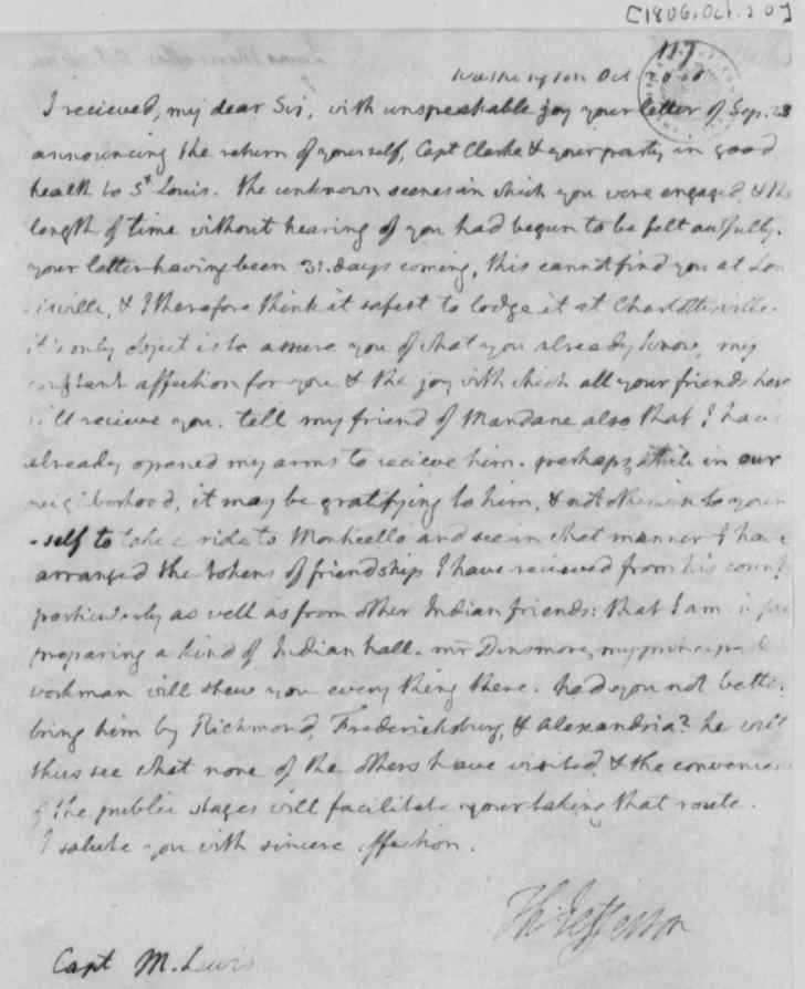
Thomas Jefferson Papers & Correspondences
243 pages of transcriptions and images of Thomas Jefferson papers and correspondences dealing
with the Lewis & Clark Expedition. Included are Thomas Jefferson's January 18, 1803 secret
message to Congress proposing a westward expedition, a February 28, 1803 letter to Casper
Wistar discussing Meriwether Lewis as leader of the expedition, an April 27, 1803 letter to Lewis
outlining instructions for the trip, and a June 20, 1803 letter from Thomas Jefferson to
Meriwether Lewis giving Lewis detailed instructions for his trip,.
Journals of Lewis and Clark
1900 pages of text transcription copied from the writings in the Journals of Lewis and Clark,
written mostly By Meriwether Lewis and William Clark, 1804-1806. Other contributors to the
journals are Sergeants Charles Floyd, Patrick Gass, and John Ordway, and Private Joseph
Whitehouse. Includes transcriptions of the raw journal entries made between May 14, 1804, the
day the expedition left the Mississippi River, to September 26, 1806, a day or two after they
arrived back in St. Louis. Includes all possible Journal entries of Lewis and Clark. Most of the
"courses and distances" and "celestial observations" have been omitted. These transcripts of the
journals includes their original misspellings, period spellings, and abbreviations
After the Corps of Discovery disbanded in 1806, many of Lewis and Clark's journals were
deposited in the collections of the American Philosophical Society at Jefferson's urging. Some
editors of the journals argued that the excellent condition of these journals indicates that they
were fair copies made after the end of the expedition in September of 1806, and prior to
Jefferson's receiving them at the end of the year. Others, however, suggest that the story is more
complex. The American Philosophical Society collection consists of 18 small notebooks,
approximately 4 by 6 inches, of the type commonly used by surveyors in field work. Thirteen of
these are bound in red morocco leather, four in boards covered in marbled-paper, and one in
plain brown leather, and there are a number of loose pages and rough notes as well. The available
evidence suggests that Lewis and Clark carried their notebooks sealed in tin boxes that were
intended to protect the relatively fragile journals from the elements. If nothing else, with
Jefferson's advising, the journals were considered invaluable as the only reliable record of data
gathered on the expedition. It seems likely, therefore, that great care would be taken in their
preservation. From a close examination of the journals and sets of loose notes, noted Lewis and
Clark historian Gary Moulton, among others, has concluded that Lewis and Clark often worked
from rough notes compiled daily, then periodically transcribed these into more polished form in
the bound volumes, however in most cases, the time between taking the notes and transcribing
them must have been very brief. On many occasions, the explorers clearly wrote directly into the
bound volumes. The journals contain huge volumes of data, going beyond geographical notes
and records of temperature and weather.
Maps
8 maps created before and after the Lewis & Clark expedition. Includes maps used by
Meriwether Lewis and William Clark in their 1804 expedition up Missouri River, with
annotations in ink by Meriwether Lewis. Also includes maps made after the expedition
utilizing information gained by Corps of Discovery. Windows is required to view maps
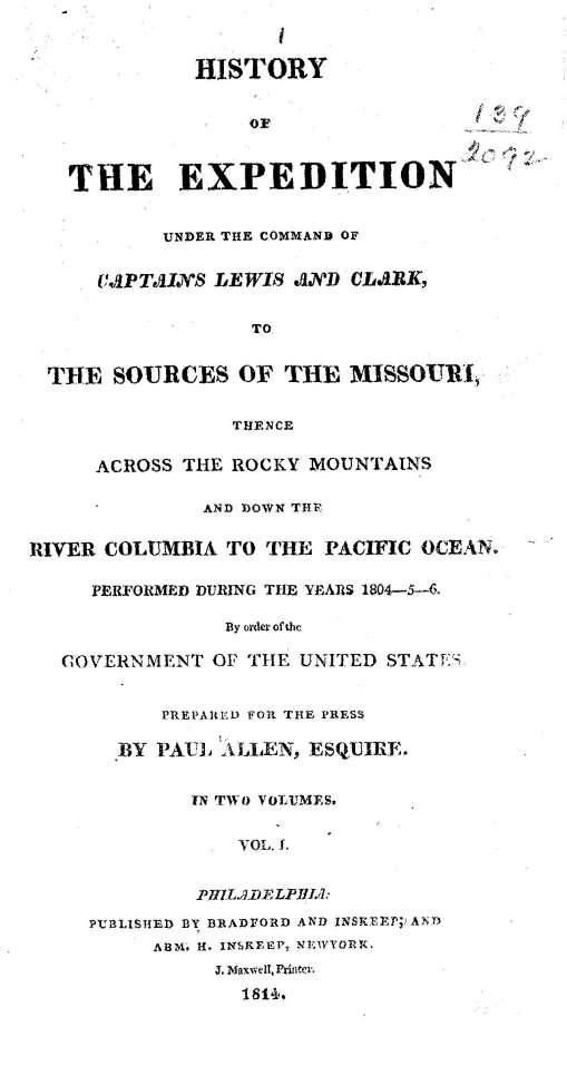
History of the Expedition of Captains Lewis and Clark Volumes 1 & 2
A digitally reproduced copy of an original 1814 printing of the book: History of the Expedition
Under the Command of Captains Lewis and Clark, to the Sources of the Missouri, Thence
Across the Rocky Mountains and Down the River Columbia to the Pacific Ocean : Performed
During the Years 1804-5-6 by Order of the Government of the United States/Prepared for the
Press by Paul Allen; Volumes 1 & 2. With a preface written by Thomas Jefferson.
After the death of Lewis, Clark, who felt that he was not up to the task, persuaded Nicholas
Biddle to prepare a manuscript for publication of both Lewis' and Clark's journals from the
expedition. With the help from Clark and George Shannon, one of the enlisted men on the
expedition, the work took Biddle two years to complete. Royalties from the sale of the published
journals were to go to Clark, but he never received a penny. Using the captains' original journals
and those of Sergeants Gass and Ordway, Biddle completed a narrative by July 1811. After
delays with the publisher, a two-volume edition of the Corps of Discovery's travels across the
continent was finally available to the public in 1814. More than twenty editions appeared during
the nineteenth century, including German, Dutch, and several British editions.
The Trail of Lewis and Clark, 1804-1904, volume II by Olin D. Wheeler, 1904
A digital reproduction of the book: The Trail of Lewis and Clark, 1804-1904: A Story of the
Great Exploration Across the Continent in 1804-1806, with a Description of the Old Trail Based
Upon Actual Travel Over It, and of the Changes Found a Century Later. New York: Putnam's,
1904. Topographer, author, and railroad executive Olin D. Wheeler, used the journals of Lewis & Clark as a guide to follow their trail. He followed the Lewis & Clark trail giving insight to the
original journey, noting the important and interesting place visited by Lewis and Clark, then by
tourists and travelers 100 years later. Volume contains photographs, sketches and maps.
First Across the Continent
An electronic book of the text of First Across the Continent: The Story of Lewis and Clark
Expedition, by Noah Brooks. Published in 1901, Brooks draws a narrative of the expedition
through the use of excerpts from the original journals of the expedition.
Timeline
A detailed 22 page timeline of the history of the Lewis & Clark expedition.
All text, transcriptions, reproduced printed text, and description sheets on the disc are indexed
and searchable. |
|